He is not the first to notice that Europe is a narrowish peninsula - even a peninsula of peninsulas - projecting west from Asia, but I don't think I have read anyone hitting the observation quite so hard or drawing so much from it. Usually, when that framing is used Scandinavia is included and sometimes even Turkey. I'd like to look at this a little differently at the moment. There are two very complicated coastlines to Europe in this picture: one in the south from the Black Sea, through the Bosporus, through many islands on the way to Gibraltar and the Atlantic; the other from Portugal through two narrow channels up to the Gulf of Finland. Ignore the lands across from these coasts at the moment, no matter how close (though you can keep all the islands in those seas as part of the picture). We will bring them back in a bit.
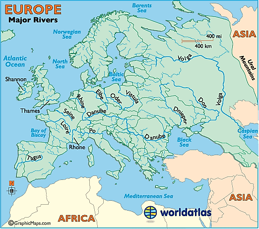
The peninsula can be transversed almost entirely by navigable rivers in many places. The Danube and the Rhine you likely knew about. The Loire and the Rhone you may have been aware of if you studied French history. But there are many other places, as short as 300 miles just above the Pyrenees, and as far up the peninsula as the Dniepr and the Don, where the crossing is still only a bit over 800 miles. The rivers emptying into the Baltic, the Dvina, the Vistula, and the Nemunas, are not as wide and navigable, but still sizable. Treat it as optional whether you include the Volga, which flows into the Caspian and was later used by the Swedish vikings, but was less of an influence on the rest of the peninsula. (Note that current political boundaries are on this map, though faint. I am considering my beginning-of-Europe boundary as running along the eastern boundaries of the Baltic States, along Belarus, and bisecting Ukraine.)
For a long while after the Little Dryas cooling period (about 10,000 BC), all of this complicated area was still mostly subsistence living, foragers and hunter-gatherers. It is important to note that these are diverse environments, with various groups settling islands, coves, littorals and fens, on up rivers to hills and mountainsides. As technology improved, there began to be trade, along coasts and up rivers. Domesticated animals and crop farming start to come in. The time periods seem long to us now, but the exchange of technology and goods accelerated precisely because there were so many varied adaptations to the incredible diversity of ecological niches. Complexity of environment leads to shared technological improvement, which leads to increased population and prosperity, which leads to...well, it leads to war, hierarchy and government, which would seem to be a high cost, but one folks everywhere have seemed willing to pay. The verticality of Peru created enormous variations in environments in just a few miles, leading to the Incas. From where the Yellow River of China empties into the Yellow Sea is complicated coastline for hundreds of miles in both directions, and this area was also a source of innovation. The fertile crescent was not only good for growing things, it had contact with disparate cultures in many directions. The Tigris and Euphrates reach almost to the Mediterranean and even the Black Sea, but flow into the Arabian Sea, opening out to a different world of cultures.
But because of a late start owing to the glacier and then the Little Dryas. it took a while for Europe to catch up. But catch up it did and the spread of technology fed on itself to create more and more extensive trade networks. Now let us add the other sides of those seas back into the picture, the coast of North Africa, Great Britain, and Scandinavia. The European peninsula did not know the interiors of those facing lands, they knew them mostly as ports. But they didn't need much else. The complicated cultures that were growing up on the peninsula(s), the LBK and Corded Ware did not much penetrate those lands across the seas, just a bit of southern Sweden and Norway. Even the later Indo-European culture, which came to dominate all of Europe, did not penetrate across water very well until much later.
The great cities and civilisations do not spring up in places of similar surrounding environments but at the intersection of them, where people can bring goods like tin, amber, wine, or metalwork that is not available everywhere. There may have thus been an inevitability to the rise of Europe once it got untracked. If we replayed the prehistory a dozen times each might look different, but I think in all cases we would have seen this rise in complexity, prosperity, and population.
10 comments:
The configuration of Europe certainly encouraged trade, but this raises the question why Europe was uniquely resistant to imperial consolidation. There were several attempts, of course, the latest now well advanced, but decentralized government is the European norm. In some cases decentralization can be explained by Europe's peninsular and insular geography. But then you have the very late imperial consolidation of the Germanies. I think some of this may be due to the frequent wars that you mention. The really old geographers said it was good for a people to be reasonably "warlike" because this was the only check on imperial servility. They deplored the excessively warlike spirit of the barbarians, but even more strongly deplored the imperial servility of Asia. They counseled moderation between extremes of pugnacity and civility. I think the geography of Europe facilitated this philosophy because the whole continent is built on a miniature scale. Pannonia could be added to the Great Plains of North America and no one would notice. Compare the plains of Lombardy to the plains of Russia. Geography is not the whole story, but the geography of Europe is an important part of its story. It allowed Europe to long realize the happy combination of economic integration (rivers and seas) and political disintegration (pocket plains). We tried to reproduce this happy combination constitutionally in the United States, but we have an imperial geography just like Russia.
Thank you for this. Excellent stuff. I recall reading Romans talking about the barbarians in just this way during the later empire, sometimes even deploring their own people for their decadence in comparison.
An "imperial geography." I have an idea what you mean by that, but I'll bet I'm wrong. Do you have a summary, or something we could read?
Most geographers today are allergic to what they call "environmental determinism." This is their name for a doctrine that they suppose existed in the past, although it really didn't. The old geographers said that geography plays an important role in shaping the character and destiny of a people, but that wise laws and institutions can to some degree mitigate the deleterious effects of a bad geographic location. You certainly know Hippocrates as a medical man, but he was also a geographer, and in his book Airs, Waters and Places, Hippocrates argued that national character is the result of geographic environment, as modified by political and religious institutions. He said that Asiatics (he was thinking of Egypt, then classified as Asia) were naturally servile because of the monotonous climate, and that their natural servility was amplified by their despotic political institutions. Europeans on the other hand were naturally spirited (warlike and jealous of their freedom) because their minds and bodies were stimulated by seasonal and topographic variations, and that this spiritedness was amplified by decentralized political institutions.
Hippocrates is obviously wrong in many particulars, but I think his overall grasp of the problem is correct. Physical geography matters, but it is not the whole story. I'm afraid that very few of the geographers who are nowadays allergic to the bogy of "environmental determinism" have read Hippocrates, or even the "environmentalists determinists" of the nineteenth and early twentieth centuries, but this is what all the old geographers really said. For a good short sample of this kind of thinking, you might read the essay "The Geographic Pivot of History" by Halford Mackinder. If you can't find a copy on line, send a message to my email address, listed at the Geography Department, Texas A&M, and I'll return a copy.
I don't have titles at my fingertips, but Russian history opened my eyes to the connection between great plains and despotic empires. Rome looks like an exception, but the Mediterranean was effectively a plain. An empire combines centralization of power with extension of territory, and it therefore requires a physical terrain that allows the central power to deliver additional force to rebellious or threatened provinces in an efficient manner. This is, of course, what Roman roads were really for. Reinforcing the permanent garrison. And a province that is exposed to external threats is more eager to stay part of the protecting empire. This is one reason Muscovy could eventually expand to the Caucasus and Pamirs.
On the imperial geography of the United States, I'll point you to the magnum opus of my dissertation advisor, D.W. Meinig. The four volumes are called The Shaping of America. A Geographical Perspective on 500 Years of History (Yale). Given what I know of your interests and tastes, I think you will like it. Dip into the first volume and see. He wrote a prospectus called The Continuous Shaping of America which you should be able to find online. If not, you can again write to me at the TAMU address. John Keegan's History of Warfare also set the old noggin Jogging. One of the beauties of Meinig is that he will open your eyes to the imperial nature of the United States, but that he does not do this with a subversive anti-American intent. He was personally a Christian and a tory, and also a highly literate gentleman.
JMSmith: The configuration of Europe certainly encouraged trade, but this raises the question why Europe was uniquely resistant to imperial consolidation.
The Alps. Compare to the Nile, Tigris-Euphrates, Yellow-Yangtze, or Mediterranean empires.
@ JMSmith - thank you again. I will look these up after I finish Cunliffe. Modern geographers may be so irritated at the idea that geography is destiny because popular writers of the mid-20th C seemed so take with it. I loved James Michener at first, though I tired of him, and he was strongly in that camp. Poland's history is that it is a flat, fertile place between Germany and Russia. The Chesapeake culture was formed by the large geography of international trade into the bay and the small geography of shallow inlets being a more efficient mode of travel than land. That sort off thing. Good stuff to awaken you to the idea of geography and culture, but that well goes dry quickly.
I think a better answer to why no imperial consolidation is the thing you started off noticing. Europe's rivers run north-south to the sea with little branching. You can only get into a small slice of the interior, and you have to cross defensible terrain to move east or west. Contrast that with the US which has the Ohio-Mississippi-Missouri basin as well as the Great Lakes to carry people far inland.
Hello. These are interesting thoughts. (Whenever I run across a topic like this, I find myself having to resist getting roped into the Guns, Germs & Steel conceptual model and taking extra effort to get at the idea here on its own terms. This residue is kind of irritating.)
A couple of thoughts come to my mind in view of the discussion here:
1. Does it matter to the imperial thesis that America discovered the Great Plains, or maybe let's say began to exploit them, only some little time after its general shape as a republic had been established?
2. This idea of the historic great cities being founded at major meeting points of different cultures and such -- to what extent does it explain the evolution of North American urban clusters?
3. Taking the premise that heterogeneity of geographic circumstances is the driver of technological innovation, what are the implications of this idea for the internet insofar as the latter can be legitimately described as a (real/virtual) macroenvironment? That is, homogenization of the internet over time, effects thereof upon the innovative landscape of outcomes.
Thank you. In no order: Greg Cochran and others over at West Hunter are quite down on Diamond. I will let him speak for himself. https://westhunt.wordpress.com/?s=diamond
#2 Hard to say which is cart and which is horse. The North American major cities were on seacoasts, river mouths, and Great Lakes, and thus had access to many places, including foreign countries. However if you look at Colin Woodard's American regions https://assistantvillageidiot.blogspot.com/2019/01/american-regions.html (or Joel Garreau's, linked within) you can see that many of them are also on the borders of cultural regions. New York metro, DC, Houston, Los Angeles, Chicago and Detroit, Montreal.
#3 The internet is also able to create communities within itself. Where this all ends up I don't have any wisdom about.
#1 That's intriguing. We have somehow developed this incorrect assumption that colonists arrived and started pushing westward pretty soon after, but the frontier camp Lexington, KY was named for the battle in Massachusetts that started the Revolutionary War over 150 years after Jamestown. We were in a very real sense had already been America for decades by the time the Great Plains entered our consciousness as something that might someday have states and stuff in it.
FWIW, I tend to think of Europe, the Middle East [or SW Asia from the Iranian plateau to the Levant and Arabia, India [writ large] and China [locked behind mountains, deserts, and forest not obvious with a political map] as the great subcontinents of Eurasia, with somewhat similar [not to be carried too far] histories of developing regional civilizations with periodic surges in from one of the others or, more often, from Central Asia, the linchpin.
The Middle East has been the most open to invasion and turmoil from that direction, Europe the only one the break out and wash over the world on its own. Though they've all influenced one another.
No particular point, just a way of looking.
I don't have much issue with any of that. I recommend The Revenge of Geography by Robert Kaplan as a good popular summary of how this has played out over the last thousand years or so - which was not my focus here but perhaps more important.
Post a Comment