Showing posts with label wayfinding. Show all posts

Friday, December 13, 2019

Wayfinding And Stonehenge - Fifth-Most Visited

Originally from 2007, republished in 2011. The search term "Stonehenge" likely drives the traffic. This was part of my larger wayfinding series.  I provide links to the whole series at the bottom, but the stone circles have their own fascination and I'll keep that focus here. There is new information about both Stonehenge and Avebury since I wrote this, but including that would make me look more knowledgeable and prescient than I can lay claim to.

******

Reading Hengeworld (four stars, review later) I learned the Negotiating Avebury project had a specific goal of (literal) POV variety in understanding the site from its outset. Archaeologists see sites in terms of overhead maps and cutaway views, while visitors navigate the megalithic sites largely by landmark. It dawned on current researchers that the builders and users of these sites had a perspective more similar to modern tourists than to modern archaeologists.

The exception of course would be during an actual dig, when the physical perspective of the excavators would be far more similar to their Neolithic ancestors. But digs are temporary and their participants few. So - now we can computer model them, creating virtual Aveburys and Newgranges, adjusting our size and perspective however we like. It should give us a picture more like the ancients saw.

Most people have a primary vision of Stonehenge that looks like this.
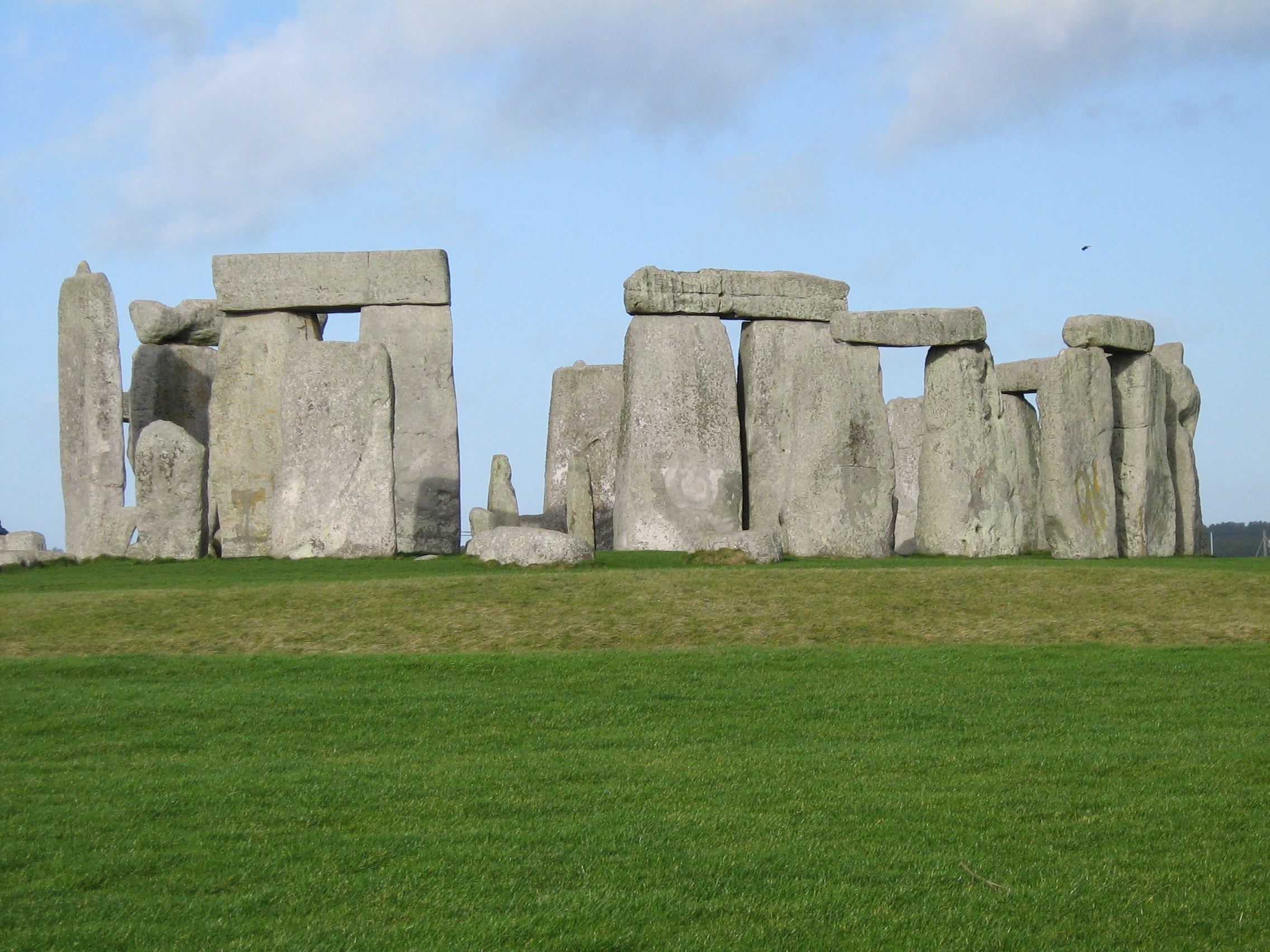


But our secondary views will be like this


Or even this, giving context.


Neither of which would have been known to Neolithic people. (But see discussion in the comments.)

Reading that convinced me immediately that the wayfinding researchers were correct in focusing on cardinal directions as opposed to overhead maps as the contrasting method to landmark navigation. I had been thinking vaguely that because one could draw an overhead map of an area in the dirt to explain it to someone else, it was therefore possible that even before maps, people had done so, perhaps mostly on a local scale. I see now this is ridiculously wrong on my part.

1) Yes, you can draw a map in the dirt, but you can't carry it with you. Carrying a map in your head only comes from frequent use of them and reference to them while navigating. Until paper and printing were common, that frequency of use was exceedingly rare.

2) Early maps were clumsy affairs, revealing that their drafters had difficulty moving entirely to the overhead position. At ambiguous areas they seem to resort to a mixed perspective.

3) Cardinal directions integrate much more readily with landmarks, the other navigational strategy.

4) The idea of overhead visualisation of an area likely increased because of long-distance sea trade (relatively recent), surveying (only common the last few centuries), and the airplane and motorcar coming into common use (very recent). What seems natural for me, born in 1953, is historically quite unnatural.

I focused on Stonehenge because is is familiar to more people, but we are partial to Avebury here. One can walk among the stones, and the bank-and-ditch are still quite prominent. I thought that gave us more of a sense of what the original observers saw, but that's untrue. The ditch was far deeper, the bank a bit higher, and it was chalk, not turf. Since 1500 BC, perhaps, the pastoral, inhabited scene of today may have been more common, but when it was first dug, Avebury was more like this.


The image is from this wonderful Avebury site, though it doesn't kick modern druids half enough on the subject. (Talk about an idea that won't die, regardless of the data.) I'll be writing more about the megaliths this week.

The entire Wayfinding Series from 2011.
Introduction, with Yankee humor. 
Update: A recent paper on spatial navigation.
More Wayfinding 2013 
Note on Wayfinding 2012
Mapmaking 
Spatial Memory 

Saturday, October 01, 2011

Recent Conversations - Wayfinding

The full discussion about giving directions and navigating, which is called Wayfinding in research.

Monday, August 15, 2011

Wayfinding - Inner Navigation II

I have discovered to my dismay that I am not as good at this as I thought. In fact, I may be quite poor at navigating, and my supposed strengths are just compensatory efforts.

Left over from childhood is my default opinion that if I am good at some brain skill, I am likely to be extremely good, even uncannily good at it. Over the years I have certainly found many examples of skills I possess in moderation, and these of course well outnumber the things I am exceptionally good at. But my working assumption is that I have the rare skill. When I first heard of perfect pitch, I immediately concluded I must have it. Upon finding I did not, I sought ways to imitate the skill, mentally keeping track of the limits of my singing range and counting up or down from that murmur to Middle C. I figured that must be what the others did naturally, but I was missing one link in the chain which I would have to build myself.

Jonsson kept mentioning that those who grew up in urban environments did not have the same intuitive navigational skills as those who grew up in other environments. Well, country people say things like this all the time, but I always assume they are just woofing, trying to elevate themselves without warrant. I took it as a personal affront. Cheeky bastard, I'll show you navigation.

Yet the examples he kept providing of the errors an expert makes seldom sounded all that familiar to me. Nor did his descriptions of wayfinding in ambiguous situations ring many bells. There were a few things which did indeed match up. The inability to overwrite an incorrect map, for example, was familiar to me. Upon my arrival at Williamsburg for college, I became introduced to the place with conflicting data, and never got a clear idea of my location in space the whole time there. I did have a powerful and accurate cognitive map of the college plus Colonial Williamsburg, so I just stayed there, mostly. Every place else I have lived, I immediately went exploring. I never did in Williamsburg.

After reading Jonsson, I wondered if it were indeed my initial map which threw me off. Checking the area with mapquest, I saw that while the entire peninsula from Richmond to Portsmouth runts NW to SE, but Colonial Williamsburg is oriented East-West. It's a navigational island in Tidewater Virginia. I assume this is because it was a planned community from the start, and the precise, educated people wanted a city that behaved in proper fashion, not one that had just grown up on its own. If one goes 10 miles in any direction from Duke of Gloucester (DOG) Street, one ends up in deep water, such as the James River. Additionally, the original, colonial W&M campus is overall an equilateral triangle, with one point at the foot of DOG St. Equilaterals are built around 60 degree angles, remember, not 90's and 45's. Yet the easternmost campus, the old campus, retains its E-W, right-angled orientation for about 100 yards into the triangle. After the Sunken Gardens, everything just goes to hell, though.

Update: For my late 2019 discussion, I decided a map might help.  One can see  the E-W of Williamsburg versus the SE-NW of the peninsula (Rtes 60 and I-64), and how the college contains elements of both.

Then, just to top it off, the two legs of that equilateral triangle, Richmond Road and Jamestown Road, angle outward a further 30 degrees at the very point they leave campus. The entire arrangement is an island of roadways that is unrelated to anything around it, but is connected in a dozen ad hoc ways to Tidewater VA. Richmond Road heads straight for Richmond for about 300 yards, then unaccountably heads to Fredericksburg for the next 20 miles. Jamestown Road is similarly approximate once it leaves campus.Tracing all this I understood clearly how my map had gone instantly wrong, and now I knew why I never could fix it.

I am very curious how all my sons, who grew up in different environments, are in intuitive navigation. For myself, I now see that my map-obsession is an attempt to compensate by brute intellectual force a rather middling inner navigational ability.

Offhand comments: I had trouble navigating London, because deep in my navigational toolkit I think of a city's river running N-S, as the Merrimack does in Manchester, my boyhood home. I learned this is a not-uncommon error.

We seldom learn the routes to places beyond walking distance until we learn to drive, at which point we are more likely to rely on maps at first.

We unconsciously smooth routes into something more regular. Winding roads straighten in our memory. Imperfect right angles become an exact 90 degrees in our cognitive map. These smoothings, necessary for memory, are the foundation of some of our navigational errors. (Tiredness, passively riding, and cloudy skies are some of the other causes.)

So have fun, rehearsing in your mind when you first came to the important places in your life, and whether you made errors in your immediate cognitive map.

Wayfinding - Inner Navigation

Tracy found Erik Jonsson's Inner Navigation for me, which adds further to our knowledge. Jonsson describes incidents of people with excellent senses of direction going wrong, making types of errors not recorded among average folks, and uses these as a window into what is happening in our brains.

I have only the vaguest idea who Jonsson was. His obituary in the San Diego Union-Tribune notes only
Sept. 14, 1922-Jan. 24, 2008. He was born in Folk, Sweden, and was an engineer. He served in the Swedish army during World War II. He was a member of the Royal Institute of Navigation and the California Native Plant Society.
That is enough to know a little something, however, and he seems entirely familiar with the research over the last 150 years. He makes dozens of fascinating observations - the book is an easy read, BTW - but for our purposes three main ones stand out.

1. We make a cognitive map of a place upon entering it, largely unconscious. (Cognitive map is a term in psychology that does not usually mean "map" in the overhead sense. In this case, it in fact means what we have called landmarks.) If there was an error in this original, it is nearly impossible to erase - and the better a sense of direction one has, the more persistent the wrong map is. The naturally expert wayfinder makes an initial structure for navigation so powerful that it is indestructible. Most frequently, these maps are misoriented by 90 or 180 degrees from the start. Forever after, the navigator cannot convince himself of the true orientation no matter how hard he tries. (The factors which cause this take up much of the book.)

2. Sense of Direction seems to operate most powerfully to the question "Where did this journey start?" People with a good sense of direction can often point back to Start with fair accuracy, even if they have not been paying much attention.

3. People who grow up in urban environments have this intuitive sense of navigation stunted or weakened. So much of the orienting work is done for them that the old, primitive sense of navigation does not develop properly. Additionally, most travel is now done at speeds which exceed our instinctive cognitive map-making abilities. We can still landmark, but it is more attenuated.

Tuesday, July 26, 2011

Wayfinding

I ran across a theory on the possible origin of gender differences in wayfinding. Hunter males, following game across landscape, needed a method that could adapt to changing circumstances, as their route home might be different each time. Landmarks would be an important supplement, so a percentage of them needed that skill in full blossom as well, but cardinal directions, orientation, ability to envision distal routes would be of primary importance.

Gatherer females would need to reliably know where fruit, medicines, supplies, could reliably be found, and so would need advanced landmark skills. The terrain or approach might be somewhat different each year, so both gestalt environments and chains of landmarks would be useful.

Like all evolutionary biology theories, plausibility is going to be easier to come by than proof. Though strong genetic evidence for these sorts of theories may not be that far away. We can sometimes determine when a trait came into being, and if it accords with the archaeological evidence of what was in fact in use behaviorally at the time, it's a good indicator.

Thursday, July 21, 2011

More Wayfinding

The Tourist, looking up at the sign, asked: Old-timer, both forks say "St. Johnsbury." Does it matter which of these roads I take?

Eben Jenkins shook his head. "Not to me it don't."

Carol Lawton of Indiana University Purdue University Fort Wayne has research showing there are significant gender differences in wayfinding, as I had suspected. Females use landmarks more often, males use cardinal points of the compass. I still cannot find any definitions which says whether the cardinal and overhead map methods are entirely the same thing.

Maybe this college that doesn't know where it is was a spur to her researching the subject. She has related research at the link.

Researchers at Taiwan Science University and University of Alabama have also found gender differences in navigation.

Here's research on differences of scale affecting testing. More interestingly, skill in small-scale navigation is distinct from skill in large-scale. They don't seem to have considered the egocentric/allocentric difference for this.

And for further exploration on your own, this paper on defining Wayfinding more precisely includes one of those nice lists of other articles that cite it, leading you on to branching research.

Wednesday, July 20, 2011

Wayfinding

The Tourist asked: Old-timer, can you tell me how to get to St. Johnsbury from here?

Eben Jenkins thought a bit, raised one hand and started to gesture up the Mountain Road. Thinking better of it, he stroked his chin and then pointed back down the River Road and almost spoke. He caught himself, looked the other way - up the River Road, and his eyes took on a faraway look. "Young fellah, you can't get theah from heah."

Some overview, before putting you on to some of the research.

Wayfinding is a subtopic under spatial memory. Though wayfinding can involve different scales of routes to follow, these are not vastly different scales. They are human sized, and involve moving a human-sized body, or objects only slightly smaller or larger. This is what human beings have navigated in for millennia. We now scale up to spatial relationships a million X larger or million X smaller, but these are recently learned. Like the Fahrenheit Scale that works best in the nice, human-living numbers 0-100, wayfinding is the understanding of movement from room-to-room, of walks in The Shire. Longer journeys of even ten miles begin to require a greater level of abstraction. This is landmark navigation, we have a hundred brain mechanisms we are unaware of helping us out, it is what we are built for, and it is far superior on the human scale. Even switching between scales at this level is not that hard.

Longer journeys, especially those which have to navigate around something large, such as a lake or a mountain range, push our brains to do either of two difficult things: either we must create a long chain of directions or we must develop a set of abstracts which allow us to store the navigational information in shorter, but more complex form. Some humans do one, some the other. Both require working memory and set-shifting, but the former is emphasised in landmark, or egocentric navigation, while the latter is more in play in cardinal/overhead or allocentric navigation. The hippocampus and prefrontal cortext you've heard of - those are key to egocentric navigation. Other cortical areas that you haven't heard much about* are key to the allocentric navigation. Allocentric seems to be later, more advanced, dependent on parts of the brain other than the most basic. That is a ridiculous oversimplification, but I think it holds.

In either event, memory storage and retrieval have to be in fine working order.

Interesting tidbit #1. Some tests of wayfinding abilities on the pencil and paper scale give a very accurate picture of how you will do walking around indoors or in a small neighborhood. Others tests give an accurate picture of how you will do on journey-length navigation of miles. For the in-between scales - from the large mall to the town - the results are ambiguous. Both types of test will stretch so far and no farther in the individual, whether scaling up or scaling down - and the stretch is a bit different for each person. The tests don't tell us much, because they begin to measure two separate things. People switch sets of scale and of method at the margins, and the tests measure something else: general intelligence, which is related to our ability to switch sets.

Interesting tidbit #2. OTOH, they tell us a lot about people who can't navigate at all. An experiment by Toru Ishikawa (and that name will show up again in later posts) showed that some students learned a route right away, others learned it gradually, and some never learned it, even after ten repetitions.

Interesting tidbit #3. (Also Ishikawa) Using a GPS interfered with people's ability to learn a route. All my map-loving readers are secretly rejoicing, but there could be problems with this study. The participants may have not been that familiar with using GPS, and relatedly, switching scales on the small screen may have thrown them off. (This was a walking test.)

There is a further possibility suggested by this. Those who rely on abstract, allocentric, overhead map navigation may not develop their landmark, egocentric navigation as fully as those who rely on it entirely. The prideful allocentrics who can navigate to Spain and back may forever be less good at getting about town than the egocentrics. The good egocentrics, that is. Obviously, everyone is better than those who haven't got a clue. Of which there are many.

Tangential humorous story about a guy who didn't have a clue. A family in a car with out-of-state plates rolled down the window. The husband, driving, asked where the cliff with all the faces were. I started to tell him where the Old Man of the Mountain was - about two hours away, but he cut me off. "No, I don't mean the Old Man of the Mountain! I mean the place where they have the faces on the cliff!" I noticed that his wife was rolling her eyes, the children in the back looking very quiet. This discussion had apparently been going on awhile before they had gotten to me.

Inside, I'm thinking Dear God, don't let him be talking about Mount Rushmore. I don't think I can break it to a guy this angry. Aloud, I said gently, "Well, there are a few others up in that direction, there's Indian Cliff, it's got a staircase observatory..."

"No, these weren't Indians."

"Well, we don't have anything as fancy or impressive as Mount Rushmore here in NH that I can think of..." I said tentatively.

"No, it's not goddam Mount Rushmore either! It's a cliff with faces on it!"

"Sorry, I've lived here most of my life, but I'm not sure what you're describing."

He rolled up the window and drove off. He waited at the stop sign a long while - I think they were arguing still - then took an emphatic left and sped through town. Left was not the direction for either Franconia or South Dakota. But you knew that.

*entorhinal and posterior parietal

Monday, July 18, 2011

How We Give Directions

We have long noted that men tend to give directions, and perceived routes in terms of an overhead map, while women tend to prefer navigation by landmarks. It's not a pure situation - I'd say it's about 80-20. My oldest son prefers landmarks, I know women who prefer overhead. But the difference is pronounced enough that when giving directions, my wife will give directions to a female, I will give them to a male.

I have not found in the scientific literature this exact characterisation, but the strongly related distinction of using cardinal directions versus landmarks is common. It may even be a more accurate distinction than the one I stumbled upon on my own.

Family history.
Jonathan and Ben are remarkably similar in abilities. Yet there was a sharp difference in the math scores of their standardised tests, which Jonathan attributes to doing poorly on spatial reasoning. As he is noticeably less comfortable with maps, this seems plausible. But we had a recent conversation that demonstrated that he has spatial memory of the landmark sort far in excess of what I can do. His memory for the layout of the church we attended 1987-91 or thereabouts was far superior to mine. In fact, I could recall only one feature of the lower floor, while he "walked about" in it effortlessly. The literature suggests were I to see it again I would find my way easily. But I am unable to recreate it. I find, in fact, that my remote memory for interior spaces is quite poor. I can only envision them by indirection: reasoning from outside appearance what must be inside, coupled with hazy recollections of single objects, building back and forth from such clues. Cheats, really. Tricks. Houses I lived in. Schools I went to. There is no interior space from my childhood that I can recreate by entering a door and walking accurately through the place.

So it's interesting that one method is considered the better by the people who make up tests, though each has places of superiority. It's not entirely arbitrary. As travel and need for distance navigation increased - and it was primarily males who made the trips - the need for this overhead mapping would be increasingly favored. It is more abstract. In terms of moving civilisation forward, it's smarter. But there is a cost, because using that ability tends to make local navigation weaker.

Landmark navigation is done much better when it is conscious, ticking off sights in the mind as they pass, but apparently a good deal goes on without effort as well. Over time, the schema builds itself. Landmark is far superior on a small scale.


One of the difficulties of navigation turns out to be switching sets, whether that is switching from landmark to cardinals or switching scale in either. For example, when going on a long highway trip I am using map/cardinal directions almost exclusively. But if I get off at an exit in search of gas or food I am thrown into a different scale. If the distance to the Cracker Barrel is less than a mile and involves few turns, I just automatically stay with landmarks, going in and out by signage, without converting it to overhead in a different scale. But as I go further down the secondary route and no Cracker Barrel has shown up, I waver, I hover between choices. I have not been creating an intentional landmark map - has my automatic landmarking been sufficient to get me back? Or should I switch to a new, small-scale cardinal? Further complicating the event might be the parking lot and entrance into the little four-business cluster which includes the Cracker Barrel, which is on an even smaller scale. Yes, I can see back where I come from, but I will get turned around twice, and as I come back to the highway, I might no longer have an intuitive sense which direction I am supposed to take it. Landmarks and cardinals have interfered with each other.

We learned the neighborhoods we grew up in entirely by landmark. My last one, in high school, I had actually already had in my overhead map before arriving, but the landmarking, far more useful on a smaller scale, overwrote the old data. The earlier neighborhoods are intimate landmark-memory sections inserted into a larger overhead now. At the fringes, my navigation-storage hovers back and forth.

If I were to color on an overhead map what childhood areas I have stored in landmark form, it would not be a circle or region, but individual streets only: between the route to my grandmother's and the route to the library there are many streets that I walked occasionally, or looked up those avenues while walking a usual route, but they are mostly stored in overhead grid in my memory. Landmarks stop abruptly at the Y, at church, at Bunny's Superette. After that it is terra incognita. At those spots I switch to overhead.

The term used in research is Wayfinding, and there are discussions of You Are Here maps, gender differences, relying on GPS, routefinding improvement, and a dozen other byways. The types of navigation are also called egocentric and allocentric, sans the connotations they have in discussions of social phenomena. I'll have some fun with these in the next post. Uh, a future post. For now, I've given all of you plenty to think about and comment on. I'll bet your guesses anticipate some of what I'll be mentioning from the research.

Friday, June 17, 2011

For Those Who Like Maps


This post is only going to be meaningful if you really like maps, or have a solid picture in your head of Route 28 from Manchester to Ossipee. Other than that, move along now. Nothing to see here. Fanatic at play. The above is a section of USGS topographic map from 1919 for the Gilmanton Quad. (Click a second time to expand.) There is a more central UNH site which will allow you to connect quickly with adjoining maps, and see Alton, or Concord, or anywhere else in New England in 1929 or 1957 Loads of fun if you like comparing roads, paths, and settlements over the years.

If you are really serious about following the roads and comparing, pull up Suncook on mapquest or googlemaps on another tab and switch back and forth. Those have the current names of roads. I am going to trace for you where Old Route 28 went. This is just the data section, not the commentary.

Hooksett to Suncook (Suncook Quad)
Starting at Hooksett, on current route 28 above Hooksett Village (above Mt. St. Mary's College on the USGS maps).
Fork left at Pleasant St, down into Suncook. (Numbered routes used to seek town centers rather than avoid them, remember.)
Right on School Street
Left on Turnpike Street

Suncook to Epsom Circle
Lower bridge to Buck Street
Left on Thompson Road
Cross current 28
Right on Bachelder Road (which becomes, tellingly, Buck Street Extension)
Right onto current 28
(Jug City Rd comes in behind on the left. Both old and current 28 followed that for a bit. I don't think Webster Park and Mitt House were ever 28. Dubbahdee?)
Left on Elkins Road (a few yards of White Tail Road)
Left on current 28 again at end of Elkins
Left on Windymere Road
Windymere used to continue on to 202 and Sawyer Road. Now it comes back just before Epsom Circle

Epsom Circle to Alton
Sawyer Ave starts just West of Epsom Circle on 202. Take it north.
Left on current Route 28
Right on "Old Route 28," a very brief parallel jaunt.
Left on Deer Meadow Road
Right on Main Street, coming out of Chichester
Merge with current 28 (at the old country store)
Left on Carpenter Road for a brief loop, then back on current 28
Left on Squiggey Brook Road for a longer loop. (These two loops used to be a connected road)
Left on Kelly's Corner Road, a deeper loop
Rejoin current 28
Right on Concord Hill Road, into Pittsfield (Seeking towns in 1930, not avoiding them.)
I think the route through town was Main Street, Carrol Street, Barnstead Road. Might be Oak Street instead.
Barnstead Road crossing current 28, still Barnstead Road
Join current 28 at end
Right on "Old Route 28" through Barnstead.
Tricky, tricky! Don't take Old Route 28 to the end! It now has that name for convenience. The route actually took a right at Rabbot Lane, snugged right on Rte 126 and quickly left on Maple Street. (This is Center Barnstead. New Hampshire towns do things like that a lot. It's insane, yes.)
Maple Street crosses current 28 and becomes Beauty Hill Road.
Right on Oxbow Road.
Return to current Route 28.
On the satellite view, a teeny jog right is visible that has no name.
No further changes to Alton. Take 11 into Alton Center.

Alton to South Wolfeboro
Old Wolfeboro Road out of Alton Center
Cross current 28, still Old Wolfeboro Road
Meet East Side Road (28A), turn right onto current 28
Right on Gilman's Corner Road
Left on Quarry Road
When Quarry Road crosses current 28 it becomes Roberts Cove Road (quite pretty).
Roberts Cove back to current 28, and a confusing bit: cross 28 onto Rines Road
Left on Stagecoach Road. Old Stagecoach Road, which was Old Rte 28, is no longer passable, but the current Stagecoach Road brings you back to current 28.
No changes to Wolfeboro Center

Wolfeboro Center to Route 16, Ossipee.
Birch Road on the left in Wolfeboro falls used to be Route 28. Blink and you'll miss it.
Ditto Allen Road on the left.
Right on Water Village Road (Rte 171) into Ossipee (which is not the same as Center Ossipee)
Left on "Old Route 28"
Rejoin current 28
Left on Isaac Buswell Road, which continues to Route 16, where Route 28 ends. And always has ended, since 1922.

Tuesday, June 14, 2011

Old Route 28

Well I took the trip, took notes, and took pictures - and it took over eleven hours to go to the Yankee Smokehouse in Tamworth and back - ordinarily five hours round trip. Finding old routes is harder than I thought. The write-up will take more than one post, but here's a preliminary thought as a Sherlocking followup to Getting Around: the utility poles are a clue as to which is the old main road versus the newer section. There is much more pole variety on those straighter roads that have been put in more recently - which is to say, the 1950's. Sometimes the "new" part of the road has no utility poles at all. There are empty sections of a mile or more, and the wires are already going along the old road quite nicely, so why change them? Or, if it is a built-up section of new road (usually near major intersecting routes), then the utility poles are much newer and the wiring more robust. Both of these make eminent sense. Yet there is a third variety I had never noticed before - slender, uncapped poles that are newer than the old primitive lines, but not especially robust-looking in terms of the amount of electricity they could handle. Route 28 has lots of these sections.

That would never show on a map, of course, but when you're on the ground puzzling over an intersection, the utility poles just lay it out for you where the main road - and hence the road that got numbered - went in 1925: there are poles c. 1925 there. Something else, or nothing, goes up the other road. Obvious once you know it. So that might have been an aid to navigation in the older times with unmarked roads: read the poles.