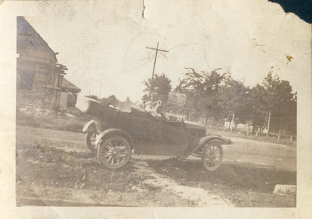
When we think of driving problems in the 1930's, we tend to think first of the cars and the road conditions. Quite natural. But the problem that would frustrate us most would be figuring out where we were and how to get to our destination. It was much more difficult then. At this well-constructed intersection of a prosperous little area of town, do you see any street signs?

Nor did the people then see any street signs. They weren't there. Towns debated in the 1930's whether there was enough money in the budget to mark the streets downtown. It is rare now to find a even a minor road unmarked for more than an intersection or two, but early in my driving career it was not uncommon at all for a road to be marked very intermittently, and only where it crossed a major thoroughfare. What street is this? Carter Street! Gold Street! Newburgh Street! Fine, fine, but what street am I ON NOW, dammit! Drivers would find themselves looking 90 degrees left or right while zipping through an intersection to see if they could read a sign deeper in. Not safe.
So those of you in your 50's, remember that, recalling areas that were slow to get with this new-fangled road-marking idea. Then project that back twenty or thirty years.
And that was in town, on the major roads. In my childhood, not every intersection was marked even in relatively prosperous cities like Manchester. Once you broke out onto the open road, all bets were off. Most drivers my age recall multiple road "adventures," creeping along looking for signs, arriving late to the event. Major routes had begun to acquire numbers in the 1920's, and by the 30's most states had at least a few. In unfamiliar territory, people clung to those route numbers as if going off them meant leaving civilisation and the safety of humankind. Because who knows what kind of people lived out there, and when anyone would ever find you if...something should happen.
Other signage was also limited. Town line markers were a wonderful aid, but you couldn't count on them being there. We must have gone too far. We just entered Hudson.. If you were lucky on a long trip, there might be a feature – a hotel or tourist trap that put up billboards scores of miles before you got there. You could piggyback on the signs that Camp Krakatoa had taken the trouble to put out. That system might break down in the last few miles, but you were happy to risk that, usually. First, you knew you were in the general vicinity of your endpoint; second, you had come to trust the nice people at that camp because of all the wonderful signs they had put out. Why, they were practically cousins.
Then there were the maps. This would have been considered a good map for drivers back in the day.
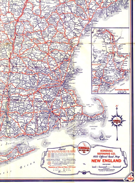
Or even a great map. Because it was more likely to be accurate than local maps. Not a lot of detail, but what you had was pretty reliable.
I am sadly familiar with what can happen when the map is not accurate. And if you have uh, an Adventurous Spirit - a euphemism for no reasonable judgment whatsoever - the combination can be dire. Relatedly, most maps gave no indication how good any of the roads were. There are many interruptions in the forest or trails through the swamp* that might in some decade have technically qualified as a "road," but that's not really what you're looking for in a map, is it? It rather felt as if county mapmakers felt obligated to keep up the pretense that Jenkins Road was still a going concern, because the Jenkins's were nice people, and the road used to be important, and we wouldn't want anyone to feel slighted. Or maybe the town fathers hadn't been out that way for three decades and missed the part where a beaver dam had buried the place twelve years ago.
Most people didn't have the map availability we do now; they didn't think in terms of maps anyway. It was rare for people to sketch out a map for you - waste of paper, don't you see - and you couldn't trust the proportions if they did. Writing out directions was cumbersome as well, because giving directions, folks were sort of estimating what you might find. Stanbright Kennels? You come up into the village, there, and you'll see a church on your right, across from a big white house with a stone wall along the front. You take a left there, that's Orchard Road, and you go about two or three miles until you pass Ames Orchard, there's a sign. And just after the sign, less than a half-mile mebbe, there'll be a road on your left that heads up Bright's Hill. There's four or five families up there named Stanton, and most of 'em keep dogs of one sort or another, so that may be the kennel you're lookin' for.
I could have exaggerated that last bit for comic effect, but I didn't. That was pretty straightforward. You hoped that the "two or three" miles wouldn't turn out to be more than five, because then you'd be second-guessing yourself for another five miles, saying to each other "Do you think he meant that farm road that went into the field? Because it didn't look like much of a road to me. On the other hand, we haven't seen anything else that qualifies." To which the reply would come "If we're on the right road at all. It wasn't marked at the fork which one was Orchard Road."
Trains were nice. Trains didn't get lost. Trains told you where you were every time you stopped. But driving out to any new place, you'd want that to rest pretty firmly on a foundation of places you already knew how to get to.
*I'm sorry, protected wetlands.
6 comments:
Ya go down this road a piece then turn left where the old Johnson place used to be.
Yeah, it's the old Johnson place, but it burned down about 20 years ago, and then the Furshlugginers moved in, started puttin' up a house, went bust and left. Place yer lookin' fer is past the old filbert orchard about 3 mile, there's a dogleg left, an' I think there's a gas station there, now.
I had a bunch of state road maps back in the '50s. Maps can be fascinating.
Oh, days of yore. Pathfinding was an art form, and men did not stop and ask for directions. They did it with magnetic organs in their heads, like pigeons.
I swear. Every time I read about someone blindly following his or her GPS into a lake I think of the "old roads".
I remember where your "adventurous spirit" led you. My favorite comment came from Amy Gagnon who asked what would have made you turn around.
I remember being driven completely nuts (and ending up wandering a mile out of my way) in old town Geneva. The roads were confusing enough, but it took me an embarrassingly long time to realize that there actually were street signs--they were just very high up and mounted to the side of the nearest building.
The lack of street signs you allude to reminds me of my experiences driving around the north shore of Long Island when I lived there a decade ago. I lived near some rather exclusive communities and on occasion had to drive to events in some of them; the experience always scared me, though, because the roads were poorly marked and mostly quite dark, and I would drive slowly as I tried to figure out where I was and where I was going, and invariably, I'd get turned around. If there was another driver behind me, they'd usually tailgate for a while and then pass me.
Post a Comment