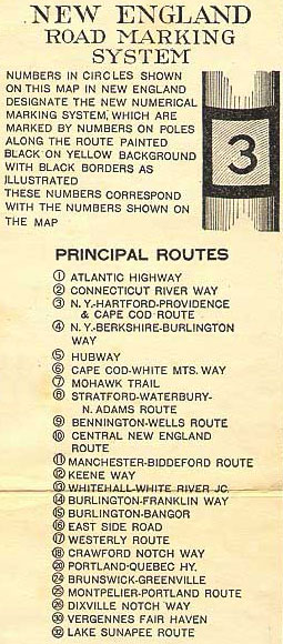
I like old roads of all descriptions, but have an especial
fondness for numbered routes. New England was among the first places to number
roads, and many of them kept their original designations as the newer numbering
systems came into play. This display is
from 1922. Because later rules dictated
that North-South would be odd-numbered and East-West would be even, Route 3
became Route 6 and vice versa. But
Newenglanders familiar with numbered roads will recognise that some have not
changed. (Those are Burlington and Manchester VT, not NH or MA, on the list.)
It includes some pretty obscure routes, such as 26 and 32. I’m not sure why
those were important enough to need numbers then, but as the surprising ones
are largely in tourist destinations, it may have had something to do with
keeping those unfamiliar with the area on track.
I have previously mentioned my interest in where numbered
routes used to go. I have looked at NH routes 28 and 101 in detail in the last
few years. The old old routes
were generally first numbered in the 1920’s.
There wasn’t much new construction; the numbered route was generally
chosen to follow the best of the roads already in place, with upgrades to
follow. The new old routes came in during the 1950’s, as states began to
build bypasses around towns and create more direct routes for longer
travel. This slightly preceded the
Interstate Highway System.
There are clues on the map of where the old route used to
go. Any secondary route which runs alongside an interstate or goes back and
forth underneath it is an automatic nominee.
For the secondary routes which are themselves under suspicion of not
being the original trail, map clues are nore subtle, but present. One looks on
either side of a town being bypassed for a route which goes off at an acute
angle into the town center; often the road runs off at a similar angle on the
other side and runs roughly parallel to the numbered route, fairly shouting
“Me! Me! I am the road formerly known as
Route 11!” Consulting the old USGS maps often confirms this, though switching
back and forth online between maps of slightly different scales can be tedious.
Yet it was greater fun to scout out the routes in person and
discover other physical clues, including my current favorite: where the
telephone poles go. All that strung wire came in during the earlier time, and
followed what were then the main roads.
When the new routes cut across open territory in the 50’s, the
electricty and phone service were already in place. New poles were only needed if new businesses
or homes were going in – and these could often be patched in from the old route
in the back anyway.
When the road you are driving has no telephone poles, it’s a
newer section. If poles suddenly come alongside, they likely ran along the old
route, and you are now driving on a section that is the old way upgraded, not
an entirely new one. The telephone poles
will then likely dive off to the side at an oblique angle, and if you are attentive,
you can see where the old road went.
Once I learned this, I recognised that I had driven nearby Rte 114 for
decades and never noticed that the road to my son’s Montessori kindergarten was
the original numbered route. It’s hardly
used now. When I have the time, I like to drive them to see the abandoned
motels and old farm entrances. Or to
simply imagine what it would have been like to drive it in the 30’s.
On my recent Appalachian Trail excursion, I noticed an
un-numbered road on the map winding in and out of I-89, at a section where Rte
10 (Central New England Route on the list above) coincides with the
interstate. Ah, I thought. I’ll bet that’s the previous track of 10.
We’ll have to stop in on the way back and see if we can confirm that by
sherlocking around a bit. Check out where
the telephone poles go. Estimate how old
the houses are. See if there are expired
businesses, or old signs giving the mileage to nearby towns.
Or sometimes, someone else has done all the work for you,
once you go and see.

That's Whaleback Mountain Ski Area in the background, BTW.
No comments:
Post a Comment